Two low pressure systems that will bring spells of very strong winds and potentially snow between Wednesday and Friday have been named.
14 February 2022
The UK is set to be hit by two storms in three days this week as forecasters warned of up to 90mph winds.
Two low pressure systems that will bring spells of very strong winds and potentially snow between Wednesday and Friday have been named.
Storm Dudley will cross the northern half of the UK from Wednesday night into Thursday morning, while Storm Eunice will bring strong winds and potentially some snow for parts of the country on Friday.
Met Office chief meteorologist Paul Gundersen said an active jet stream is driving low-pressure systems across the country, both of which are likely to cause some disruption.
Strong winds will cross western Scotland and Northern Ireland on Wednesday evening, pushing eastward to northern England overnight and through Thursday morning.
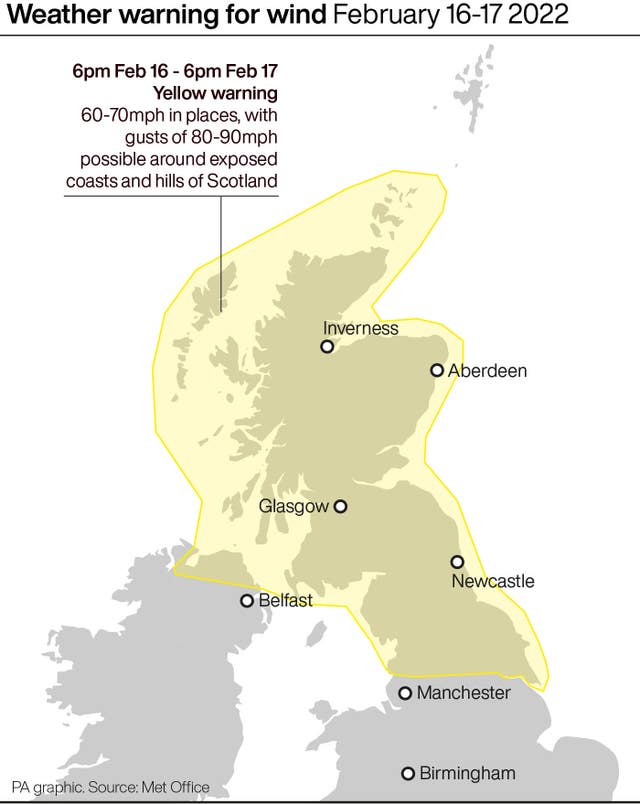
Wind gusts of 80mph-90mph are possible on exposed coasts and hills of Scotland, with 60mph-70mph possible further inland.
Winds are expected to ease through Thursday afternoon and evening, forecasters added.
There is currently an amber weather warning in place for the northern half of the UK on Wednesday and Thursday, with “significant disruption” expected.
The next low pressure system will track across central areas of the UK on Friday as Storm Eunice arrives.
Further impacts are expected from very strong winds, with 60mph–70mph gusts possible inland, perhaps even stronger in some places, though the strongest winds and worst-affected areas are uncertain at present, the Met Office said.
This system is also expected to bring some heavy rain and there is a potential for some significant snowfall over hills in the Midlands and further north.
A Met Office spokesman said: “With regard to Storm Dudley, snow will mostly be on high ground, with the highest accumulations in the Grampians.
“Lower down, any snow is likely to be short-lived but when it is coming down it is likely to be blizzard conditions.”